Featured

This man is walking across America. South Carolina is his most-perilous stretch yet.

By Benjamin Simon bsimon@postandcourier.com

Published Fri Feb 09, 2024 5:00 AM EST

GREENVILLE — In South Carolina this week, you might have seen a man walking along the highway.

He wears a neon vest, a pair of running shoes and pushes a stroller painted with white words: “I walked here from Washington.”

You might have seen him along state Highway 93 near Clemson or Falls Park in downtown Greenville or anywhere from Spartanburg to Lake Wylie.

His name is Holden Minor Ringer.

The 25-year-old Dallas native is walking 5,000 miles across the country, from Washington state to Connecticut. Since March 2023, he has trekked over 3,600 miles through 12 states, past farms in Kansas, skyscrapers in Atlanta and now the highways of South Carolina.

“Every day is a new opportunity to learn something new and see a new community,” he said. “And try not to get hit by cars.”

It started as an adventure in the midst of post-graduation uncertainty, with hopes of showing just how walkable — or unwalkable — America is. 

The Post and Courier spoke with Ringer in early February as cars vroomed in the background on East North Street, part of a 25-mile day trip that would end in Spartanburg.

South Carolina has been of particular note on his journey: He’s yet to walk through a state as dangerous to pedestrians.

From 2016 to 2020, South Carolina ranked third in the United States in average deaths per 100,000 people, according to the nonprofit Smart Growth America. Three areas — Charleston-North Charleston, Columbia and Greenville-Anderson — ranked in the top 20.

It’s an issue that Greenville County knows all too well, where 193 pedestrians died from 2007 to 2021 — the second-highest total in the state, according to the National Highway Traffic Safety Administration.

“People die, and it’s because the infrastructure is designed solely for cars,” said Frank Mansbach, executive director of Bike Walk Greenville, a local group that advocates for safer walking and cycling. “And we’ve had that happen in America since World War II — suburban sprawl.”

Why are so many pedestrians dying on South Carolina roads?

How a cross-country walk began

In May 2021, Ringer sat in Robert Woodruff Library at Emory University, trying to study for an international finance test. Graduation was looming with no post-college plans. Rather than studying, he stared out a window, watching squirrels, daydreaming.

“I kind of wanted to be anywhere but there,” he said.

The former college cross-country runner took a walk, where a thought formed. He Googled people who had taken walks across the entire country.

That was the seed, as Ringer called it. But his nationwide journey didn’t originate there.

After graduating from Emory, he moved to Everett, Wash., where he participated in a yearlong AmeriCorps VISTA program.

Then, for the December holidays, he returned home to the Dallas area. After his mother tested positive for COVID, he took another walk — one that turned into 20 miles. His mind returned to those cross-country walkers.

From there, it swept into motion. He finished his job, sold his furniture, sold his car and inherited some money that helped him fund the trip. He did overnight camping trips, including a nine-day practice run from Vancouver to Seattle.

This past spring, he started on his trek full-time.

But he doesn’t just want to walk by himself. He wants to speak with the media, talk to local advocates and serve as a voice for safer streets, partnering with the national nonprofit America Walks in an effort to increase walkability.

“We just have built our cities and built our communities, the places where most people live, to be hostile toward everybody outside of a car,” he said.

How one old book took a South Carolina man on a 500-stop, worldwide barbecue journey

The ‘most-hostile’ state 

Since March 2023, Ringer has spent 11 months walking through Washington, Oregon, Idaho, Colorado, Kansas, Missouri, Illinois, Kentucky, Tennessee, Georgia, South Carolina and North Carolina.

He logs about 20 to 30 miles per day, carrying his tent, sleeping bag, food, water, postcards, stretching gear and a GPS tracker in his stroller. Over time, his endurance has improved, though something always seems to hurt — his stomach, a leg, a bruise.

Some nights he stays with friends. Other nights, he camps outside, respites with people he meets along the journey, or buys a hotel room.

Recently, he crossed Georgia into South Carolina, planning to go from Clemson and then through the Upstate to Charlotte.

Outside cities like Greenville, Greer and Spartanburg, he found South Carolina to be the most-hostile area to pedestrians that he’s experienced.

As he entered South Carolina along U.S. 123 and State Highway 93, he saw less sidewalks than he expected.

He walked along S.C. Highway 124 into Greenville and didn’t step on a sidewalk. He had to sprint between cars over a bridge that didn’t have a shoulder. He saw a woman in an electric wheelchair in Seneca puttering along the side of the road as cars sped by at 40 to 50 miles per hour.

“A lot of people have this assumption that I’m just some crazy daredevil person who’s walking on roads that nobody ever walked on,” he said. “But literally everywhere that I’ve walked, no matter how awful it is, I’ve seen somebody else walking.”

In Greenville County, Bike Walk Greenville has sought to develop safer streets in the area. It found that 97 percent of the population needs a car to complete most duties, according to data from WalkScore.

Even as pedestrian deaths rise in Charleston area, sidewalks remain low priority

In many communities throughout the Greenville area, the issue comes down to a lack of sidewalks, specifically in the county and low-income neighborhoods, Mansbach said. In 2014, the county found that only 17 percent of streets had sidewalks.

But Greenville isn’t the only place. Across the state, sidewalk construction projects have lagged behind other infrastructure priorities, fueling the number of pedestrian deaths, a 2022 Post and Courier report found.

“The reality is — it’s very hard,” Mansbach said of funding road infrastructure projects. “You’ve got to be pragmatic. What can happen possibly? Things happen when you have elected officials that understand the quality of life.” 

It’s not just a lack of sidewalks. It’s high-traffic, high-speed, multilane “stroads” with few crosswalks, such as White Horse Road and Wade Hampton Boulevard, where together a total of nine people were killed between 2021 and 2022.

Ringer had seen roads like this all across the South.

“(South Carolina) has a lot of similarities in terms of other Southern states,” he said, “where you have a lot of big cars, a lot of people driving pickup trucks, a lot of high-speed, wide roads without any shoulders.”

Ringer’s journey hasn’t all been negative. All across the country, he’s been blown away by the kindness of people who provide him with a room and share their worlds with him. He’s met state representatives, hung out at the Swamp Rabbit Café, received a free meal at a diner in Missouri and been featured on CNN.

He stayed the weekend in Greenville, visiting the M. Judson Booksellers, the pink Trap Church, Falls Park and Swamp Rabbit Trail. He stayed downtown, which he described as walkable, showing the potential of a place with more pedestrian access.

“What’s really cool about seeing that was Friday, Saturday night, those are the places that people want to be,” he said. “Those are these destinations where people are forming community.”

What’s next? Well, first, Ringer will keep walking. He’ll make his way up to New Haven, Conn., where he’ll end his journey and where his grandparents are buried.

After that, he doesn’t know. He’s thinking about writing an autobiographical novel. Or maybe not. If there’s anything he learned from the trip, it’s embracing the unknown — and seeing where a walk takes you.

Sunday February 11, 2024 print edition

We were pleased to see that this statewide issue was featured in the Sunday paper. 

Hopefully this story will result in more awareness by our state legislators that significantly more funding is needed to make the 41,000 miles of SCDOT maintained roads safer for the pedestrians that live along these roads.

Walk2Washington on Instagram

Holden Ringer has been posting on Instagram every day of his walk. On February 11, 2024 he provided his observations about walking in South Carolina:

This photo he took in Unity Park was part of this Instagram Post
Featured

The 2023 Trail Counts Are In!

A major takeaway from 2023 is how data collection strongly reinforces our advocacy for active transportation choices.

It also backs up what we already know: people in our community love safe infrastructure for biking, walking and rolling. 
 
Our successful fundraising campaigns allowed us to donate the two display counters on the Prisma Health Swamp Rabbit Trail.  The Greenville counter went live in February 2022, and the Travelers Rest Counter started counting in March 2023.
 
Our agreement with the cities is that they own the data, but we have access to the counter website, and we provide reports to the cities for them to share.
 
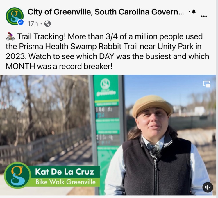
We prepared a year-end report of the 2023 data for each city, and we were delighted that the City of Greenville told us they would do a video presenting the data.  Our board member Kat de la Cruz agreed to be in the video.
 
Please take 90 seconds to watch the video that was posted on January 5th on the City of Greenville Facebook, Instagram, and X social media feeds.

Watch the video on Facebook at this link

Data is so important to the City of Greenville that they have purchased three new non-display counters that were recently installed. The additional information provided will be very informative as the work toward a more comprehensive trail network in Greenville continues.

We look forward to this new data in 2024:

  • Located at the top of the ” paper clip,” near the bridge over Laurens Road
  • Located at the entrance to Falls Park at the Church Street Underpass
  • Located at the Hincapie Path entrance on Woodland Way  south of Cleveland Park

Featured

Travelers Rest Transportation Analytics Software Analysis

Thanks to a generous donation to our non-profit in December 2022, we have been able to provide valuable transportation analytics by learning and using our analytics software.

In using this software we are able to advocate for more safe walking and biking infrastructure with compelling facts about how our existing infrastructure is used.

As a courtesy to the City of Travelers Rest we have shared this information with City Council and staff, and commented that such a report would otherwise be available only from a private consultant at significant cost.

89 Metro Areas in 26 states are the homes to 30.7% of SRT TR Bike Riders who do not live in the Greenville-Mauldin-Easley Metro Area

Transportation Analytics Software, sometimes referred to as “big data analytics,” uses data derived from location-based services from cell phones, and gps devices.  

Billions of points of data, that are anonymized provide the interesting information in our report.  The software knows where the cell phone user sleeps each night, and visitors to Travelers Rest are identified as such because the software knows the cell phone owner’s neighborhood.

A non-home-based trip begins at a location other than home (or work). An example would be someone who lives in Greer and drives to Unity Park in order to ride his bike to TR for lunch with friends.

A home to work trip is just that, a person commuting by foot or by bike.

A home to other trip is going to a meeting or going shopping or to a restaurant by foot or by bike.

It knows the census block tract (neighborhood or general area) not the exact location.

Thus demographics, such as education, or ethnicity, the software uses the socioeconomic data at the census block level.  When we report that 5% do not have access to a motor vehicle, that information is also available for each census block in the US.

Featured

The Growth of Bike Infrastructure in the City of Greenville

The growth from the first city bike lane in 2005 to the plans for repaving including new bike facilities in 2024 is impressive. One mile to over fifty-seven miles in 19 years.

By documenting this dramatic increase in miles of on-street bike facilities we can celebrate the city of Greenville’s commitment to active transportation.

In September 2023 Calin Owens the City Mobility Coordinator provided an update to City Council that included this slide:

Seventeen miles of trails means the Prisma Health Swamp Rabbit Trail as well as the multi-use paths adjacent to city streets such as Verdae Boulevard.

36 + miles of “on-street bike facilities” mean bike lanes, shared use markings where the street geometry prevents a full bike lane and signed on street bike routes such as the Laurens Road bypass.

City residents have seen an increase in green paint on our streets in the past few years, starting with Cleveland Street in December 2020.

The multi-use paths along Verdae Boulevard, South Hudson Street, and Willard Street are examples of major investments in safe biking and walking infrastructure.

South Hudson Street Multi-Use Path July 2022
July 2022

By the end of 2024 when the repaving projects are completed twenty-two percent of city street will have bicycle facilities.

Conclusion

Our companion blog post Two Decades of Advocacy gives credit to the citizen volunteers that have made this change possible and also credits the four city staff members that have implemented the projects.

The Mayor and the City Council members that have provided funding for the bike projects are ultimately the people we must thank the most for this dramatic growth.

Featured

Two Decades of Advocacy

Successful advocacy takes time. This is the story of the dedicated volunteer advocates who have worked diligently for safe bike infrastructure in the City of Greenville. I am proud to share it with you.

Left to right, Jason Van Driesch, James Thomas, Scott McCrary, and Frank Mansbach have all served as
Greenville Spinners Bicycle Club Advocacy Chairs.
Beginnings

In 2004, Jason Van Driesch became the first Greenville Spinners Advocacy Chair. He was not into group rides but joined the Spinners for this cause—no other organization represented active transportation bike riders at the time. James Thomas soon joined Jason in advocating for city infrastructure.

The Greenville Spinners Bicycle Club were the first advocates.

In 2005, the Greenville Spinners drew up the Proposed Downtown Cycling Map. Greenville City Council approved it that year. The map shows the first bike lane on River, Richardson, and Townes Streets. This was the first advocacy victory for Jason and James.

James Thomas on the Founding and Impact of Bikeville

In 2007, James Thomas took on the position of Greenville Spinners Advocacy Chair. Thomas provided this history of the City of Greenville’s staff support for advocacy and its progress:

2007 “Andrew Meeker joined the city staff as a landscape architect. He soon started the “Bikeville” meetings leading efforts towards a City Bicycle Master Plan in 2011.”

2008 “With Bikeville we suddenly had a core group of resolute advocates who were meeting monthly. We had city staff members from most departments in attendance at the meetings. Bikeville’s ongoing dialogue and diverse representation was crucial to really developing a community of bike advocates in Greenville. Bikeville changed the minds of the city staff and city council about the value of bike infrastructure.

“Bikeville also started because we needed a group of citizens and city officials to meet regularly. With it, we were able to successfully apply to the League of American Bicyclists to become a “Bicycle Friendly City “

Left to right, Bradun Dunbar, Sally Nicholson, Gregg Alley, Brian Graham, James Thomas,
Andrew Meeker and Elise Dunbar
celebrating the Bicycle Friendly Community Designation.
Scott McCrary has memories dating back to this time

“I took over from James Thomas as the Spinners Advocacy Chair in 2009 and engaged in helping move forward many of the city efforts.

Andrew Meeker was the main driving force while I was on the Spinners board, and so working with the city’s Bikeville organization was easily the most fruitful way to accomplish advocacy.

The adoption of the bicycle master plan in 2011 and the designation of Greenville as a bicycle friendly community, were notable achievements in that period. There were additions to the city bike lanes, including the Laurens Road corridor and near the city center. 

I also had a personal focus on the Swamp Rabbit Trail, an effort newly spearheaded by Ty Houck with Greenville Rec. This included my renovating the site now owned by Swamp Rabbit Café. “

As all SRT users know the café has been a spectacular success, and clearly Scott was a big part of the story.

Bike Walk Greenville’s Advocacy

I became the Spinners Advocacy Chair in 2011, and my serving in that position provided a great learning experience and launched me as an enthusiastic advocate.

2013 Edward Kinney, employed as a senior landscape architect, took over leadership of Bikeville as part of his duties.

2015 Bike Walk Greenville commenced advocating with the city in October.

2016 Citizen volunteers partnered with the city to build the demonstration protected bike lane project on E. Broad Street in May.

The citizen volunteers who applied tape to East Broad Street for the first protected bike lane in South Carolina on May 26, 2016.

2017-18 Volunteers met frequently with Edward and other staff members to discuss potential new projects.

Over the years, Edward Kinney’s responsibilities increased, allowing only 10% of his workload for biking infrastructure projects. The Bike Walk Greenville Board recognized the need for a full-time staff person and started advocating with city leaders for that position.

2019 The City of Greenville created the position of City Mobility Coordinator, resulting in the hiring of Calin Owens. Bike Walk Greenville considers this our most important advocacy win.

Having a full-time staff person has rapidly accelerated the city bicycle network that we document in The growth of bike infrastructure in the City of Greenville.

The Power of Advocates

Over the last two decades the citizen advocates who have helped convince the City Council to invest in safe bicycle infrastructure have all been volunteers. Because they cared so much, they all found time to do so in their busy lives.

Since we formed Bike Walk Greenville as an all-volunteer non-profit 11 years ago, the number of volunteers that have joined in our advocacy efforts is significant, and we thank all who have done so.

We sometimes even had press coverage when we advocate as was documented in our blog post from 2020, How one City Council Agenda Item led to a 30-minute discussion about safe biking infrastructure.

Citizen advocates have had a significant impact on moving the city forward that aligns with the inscription on our SRT girl on a strider bike statue, “we all need a safe place to walk and ride a bike.”

Of course, advocates do not do the work to implement the projects we advocate for. Thank you to the four city employees who have helped make Greenville a city far safer for people on bikes than two decades ago.

Left to right are Andrew Meeker, Brian Graham, Edward Kinney, and Calin Owens
Photos from their LinkedIn Profiles
The 1995 Bikers Map

After we published this post, Hank McCullough, who served as the Greenville Spinners President in 1996, reminded us of the efforts that were underway in 1994 that led to the publication of this map of 12 bike routes in Greenville County that included three in the City of Greenville. Greenville Spinners Bicycle Club volunteer Dave Heitz served on the the Greenville Bicycle Committee and provided an update on the Nov-Dec 1994 Yarn Spinner newsletter that were in the Spinner’s paper files of the progress being made on this map.

Volunteer advocates have been working on safe biking infrastructure in the city for three decades, not two. A long journey indeed!

One of three bike routes in the City of Greenville included on the 1995 Biker’s Map
Featured

I am a Swamp Rabbit

Left to right are Nathaniel DeSantis, Ty Houck, Anne Heaton Sanders, Jordyn Atagi, and Elizabeth Hendrix

Furman University graduate students in strategic design were looking to make a 60 second video as a class project this summer, and Ty Houck, the Director of Greenways for Greenville Rec won the competition for a free video. Ty asked Anne Heaton Sanders, Jordyn Atagi, and Elizabeth Hendrix to produce a video about the economic engine of the Prisma Health Swamp Rabbit Trail (SRT) that could be used by the County to help interested communities to learn about the impact of the SRT and also be used by the County to promote tourism in the community.

Ty recruited three people to be the “Swamp Rabbits” featured in the video: Travelers Rest Mayor Brandy Amidon, Swamp Rabbit Cafe and Grocery co-owner Jacquelin Oliver, and your blog author Frank Mansbach who volunteers as Executive Director of Bike Walk Greenville.

A script was prepared and on June 27, the three Swamp Rabbits were videoed along the trail from Travelers Rest to Unity Park. The three students put in a very long day and had many hours of video, including numerous drone shots they had to edit down to the 60 seconds time limit.

On July 11, Ty Houck hosted the team pictured above at the Greenville Rec offices where the video was shown to Ty and a room full of fellow Greenville Rec employees. There was a very positive response from the employees, that then followed a series of comments and suggested edits needed for the final product.

The students wrote, “The Prisma Health Swamp Rabbit Trail supports Greenville and surrounding communities in mental, physical and financial health. As Furman Masters students, we were honored to capture the beautiful scenes and stories on the trail. We are proud to present this video and even more proud to be Swamp Rabbits. Presented by: Anne Heaton Sanders, Elizabeth Hendrix, and Jordyn Atagi.”

The Video
Featured

Bike Route from Berea to Downtown Greenville

We studied the community near the White Horse Walmart to look for safety improvements for people on foot and people on bikes. We found that:

  • 8.5% had no access to a motor vehicle.
  • Data showed hundreds of people walking and biking to work each day.

We met with SCDOT traffic engineers and learned that there was no funding for needed safety solution such as lighting along White Horse Road.

SCDOT did agree to a low-cost project to install wayfinding signs for a bike route to downtown Greenville.

Our board approved the development of a public-private partnership to make this happen.

We studied various alternatives, and decided on a 2-mile route from the SRT at East Bramlett then to Willis Avenue, Gentry Street and Pendelton Road ending near the QT Station at SC-253 and White Horse Road. These roads are all SCDOT maintained, with low traffic counts.

Board Member Dr. Carl Anderson led our community outreach in partnership with LiveWell Greenville and the Hispanic Alliance to get feedback on our wayfinding signs project.

83% of respondents to our survey would use the bike route. The community agreed the signs should say “Bike Route to Berea and White Horse Road.”

Greenville County Council members Benton Blount and Dan Tripp have generously sponsored a Community Project Grant for the way finding signs.

SCDOT has issued the encroachment permit, and on October 24, 2023 the Greenville County Sign Shop led by Daniel Owens installed the signs.

Below are seven photos taken during installation:

Ty Houck with Greenville County Rec helped us to meet the fundraising goal with this video.

On October 25, Peyton Furtado with WYFF News 4 covered this project on the evening news.

On October 26 the Greenville Journal published a story by reporter Megan Fitzgerald

On October 30 and 31 WSPA News 7 did a report by Chloe Salsameda that was broadcast on several newscasts.

This extensive media coverage has been very gratifying to our non-profit as it is clear that the community welcomes this small project.

Featured

In Memorium: Pedestrians and Bicyclists in Greenville County

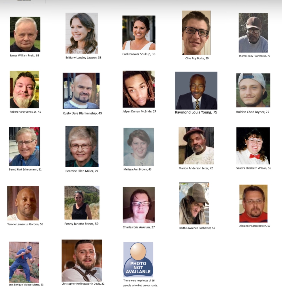
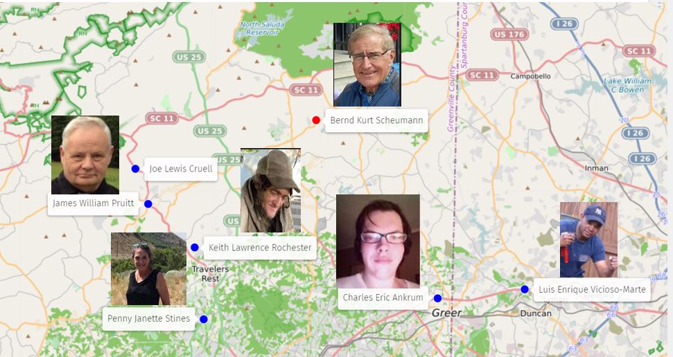
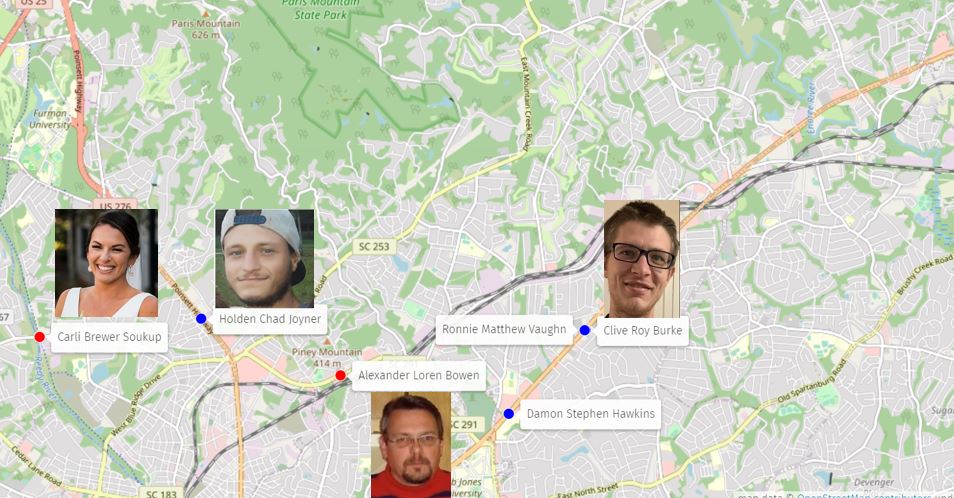
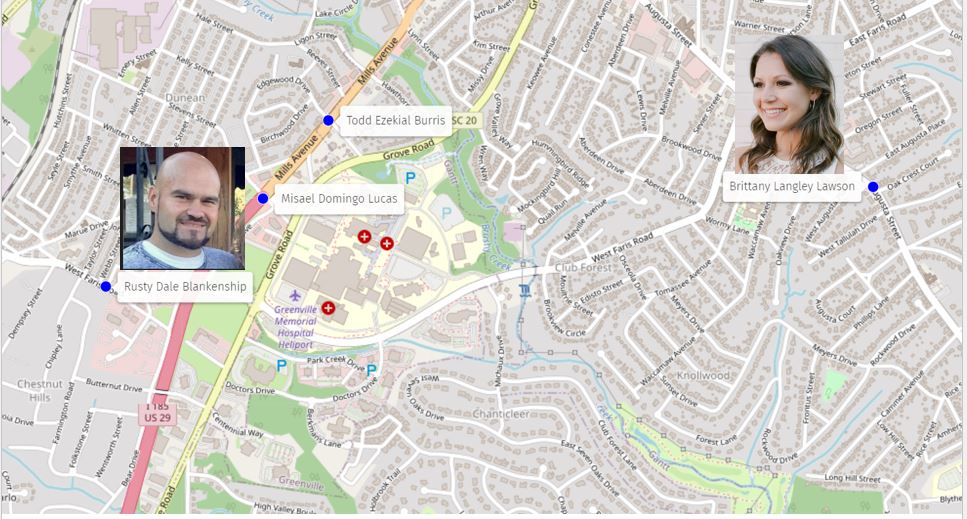
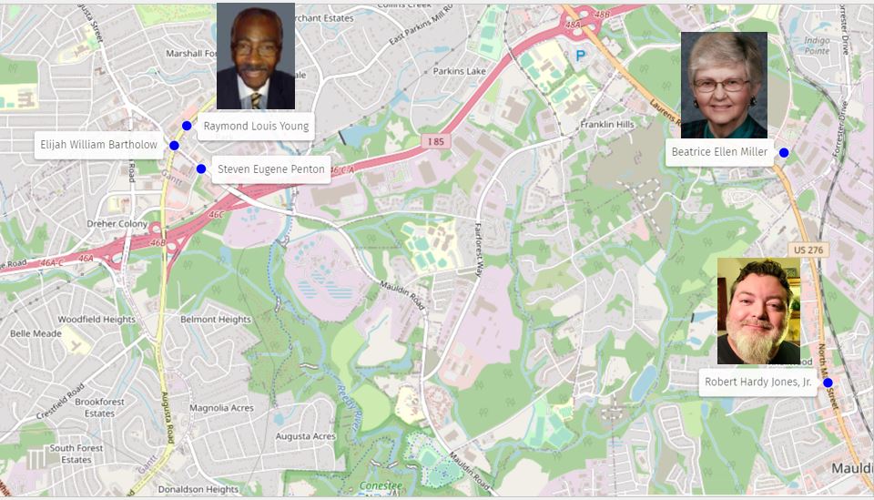
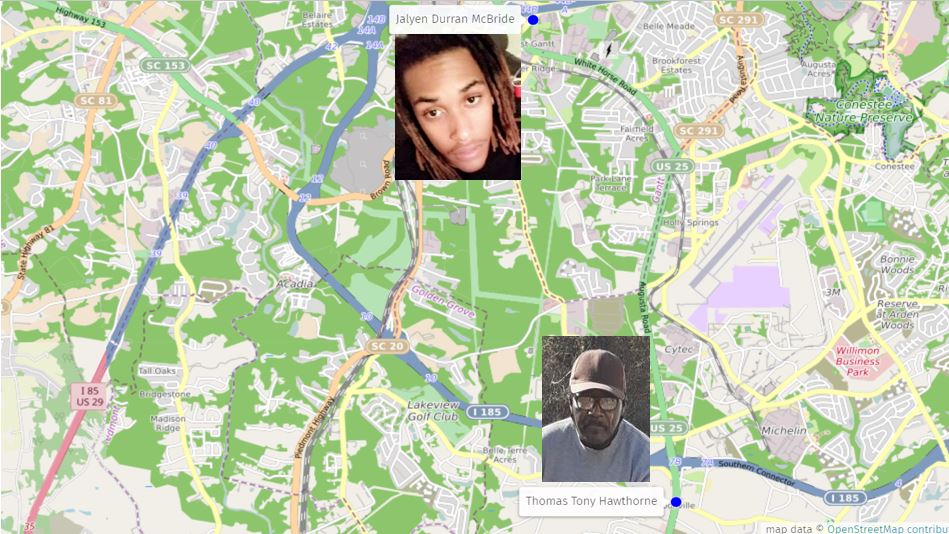
Photos of people on foot and people on bikes who died on Greenville County Roads in 2021 and 2022

Our non-profit has been studying the Dangerous by Design roads for several years, and have concluded that funding to improve these roads with more crosswalks, wider sidewalks, lighting, and other safety improvements is elusive. You can read our report about White Horse Road at this link.

Our condolences go out to all of the families and friends of those named here.

We reached out to the Greenville County Coroners Office and they provided us a list with the details of the 38 people who died in 2021-2022.

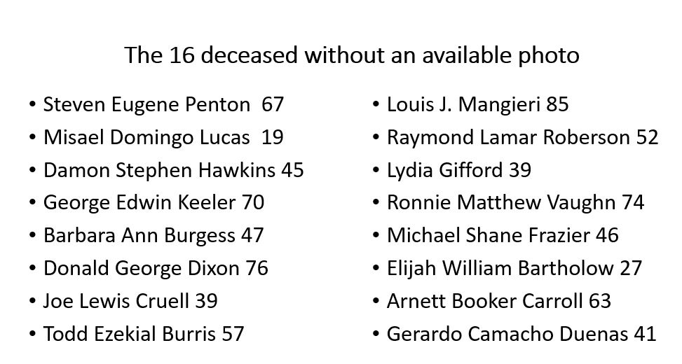
We then researched online for obituaries and news reports to learn more. We found photos of 22 victims who died in the past two years.

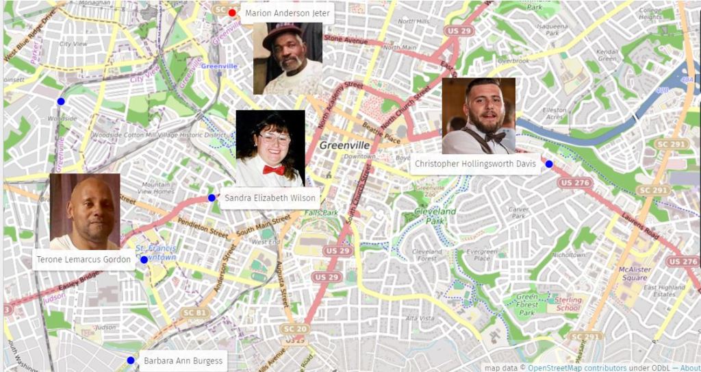
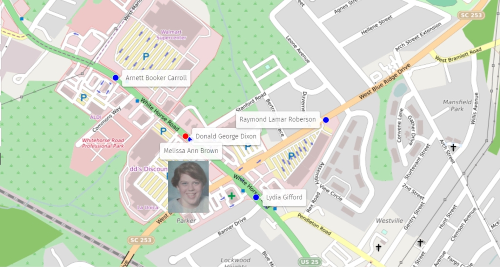
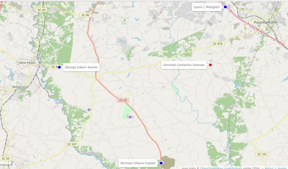
We used Open Street Maps to drop pins of all the fatalities that you can find at this link. In order to display the photos of those who died, we created screenshots with their photos.

Fatalities of vulnerable road users have been on the rise nationwide, and Greenville County is clearly part of this trend.

If you are a friend or family member of the 16 deceased without an available photo, please contact us at info@bikewalkgreenville.org

2021-22 Deaths near downtown Greenville. Blue dot is for pedestrians, Red dot for bicyclists
2021-22 Deaths near White Horse Road Walmart
2021-22 Deaths in Northern Greenville County
2021-22 Deaths on Sulphur Springs, Poinsett Highway , N. Pleasantburg and Wade Hampton
2021-22 Deaths on Mills Avenue and Augusta Street
2021-22 Deaths on US-276, S.Pleasantburg and Mauldin Road
2021-22 Deaths in Southern Greenville County

Thanks to Kelci ODonnell for her great reporting on WSPA 7 News. She reported from White Horse Road live on the 4:00 PM, 5:30 PM, and 6:00 PM broadcasts on July 14, 2023 The full report is at this link

CBS news aired this excellent 7 minute report on July 9, 2023 about pedestrian deaths on roads similar to White Horse Road, Wade Hampton Boulevard and Poinsett Highway that are designed to move motor vehicles with little consideration of the lives of people on foot who live along such corridors. Please watch the video to learn more about possible long term solutions.

Featured

The Economic Engine of the SRT

On May 11, 2023 we prepared a slide presentation for a local conference about development along the SRT, as well the data our non-profit is committed to providing to help drive future public and private investments in the Prisma Health Swamp Rabbit Trail Network.

On August 8, 2023 The Post and Courier published a Commentary that our Executive Director wrote at their request following the openimg of the green line extension.

Featured

Road Safety Audits

A Road Safety Audit (RSA) is the formal safety performance examination of an existing or future road or intersection by an independent, multidisciplinary team. It qualitatively estimates and reports on potential road safety issues and identifies opportunities for improvements in safety for all road users.

SCDOT has conducted three RSAs in Greenville County in 2023, and Bike Walk Greenville has served as part of the independent review teams to share feedback on potential safety improvements for pedestrians and cyclists.

Wade Hampton Boulevard

The most recent RSA on April 26-27, 2023, was for Wade Hampton Boulevard (US-29) from E. Lee Road to Watson Road, an 8/10-mile segment along a seven lane 45 mph corridor with no sidewalks, where 311 crashes were recorded from 2018-22. The average daily traffic count in 2021 was 41,000 vehicles day.

This road is classified as “Dangerous by Design” by Smart Growth America because it has been designed to move motor vehicles through an area quickly with no regard to the safety of vulnerable road users (“VRU’s”)- people on foot and on bikes.

In her book Right of Way-Race, Class, and the Silent Epidemic of Pedestrian Deaths in America author Angie Schmitt describes roads such as Wade Hampton Avenue, where statistically the poorest people die because of the car-centric design.

The Pedestrian Crash Summary in the RSA packet, led us to question other members of the RSA team about the “primary contributing factor.”

The Greenville County Sheriff’s office representative responded that, “his experience was that many people want to commit suicide by lying in the roadway, and he has observed others who just wanted to keep warm by lying in the road on a cold night.”

“Improper crossing,” or “illegally in the roadway,” applies to every person who crosses the 7 lanes of traffic to get to where they need to go. Three such crossings resulted in death.

The Wade Hampton Fire Department representative said that there were a lot of very poor people and many homeless people crossing Wade Hampton, and only one pedestrian push-button signal, with no marked cross walk at E. Lee Road.  The other signal is at the Walmart Super Center and Aldi at Tappan Drive, with no crosswalk and no pedestrian push-buttons.

Available data shows that many of the pedestrians in this area live in the mobile home park near Publix.

Greenlink Route 508 serves in this segment that provides service to downtown Greenville.  One of the RSA participants is a Greenville County employee who lives in the RSA area. He commented that he has parked at Walmart and taken the bus to work, but is always very nervous about crossing to get to his car from the return bus stop on the northbound side. 

The challenges towards effective solutions

The RSA team agreed that an upgrade of the two signalized intersections must be done with proper crosswalk markings and pedestrian push-buttons and count-down displays to at least provide the option of a marked crossing to use. We know from studies of other locations in Greenville that mid block crossings where crosswalks/lights are not present will still occur. This is for several reasons: it is human nature to take the most direct path/route, especially when moving on foot; intersections also can pose risk of vehicles not stopping or obeying traffic signals from numerous directions, and many vulnerable road users opt instead to cross where they can look left and right for motor vehicles.

With the high motor vehicle count, adding another traffic signal to stop motor vehicles was not up for discussion.

At the RSA for Poinsett Highway on March 26, 2023 there was an interesting discussion about the Hawk signal that only turns red for motorists when a pedestrian pushes a button. As shown below, this design minimizes the crossing length of Poinsett Highway with a center refuge island.

Unfortunately, SCDOT data shows that the area residents and pedestrian users rarely push the button. Most people cross Poinsett on foot along their direct walking route rather than navigating to the crosswalk and stopping traffic at the signal. The SCDOT data is backed up by our own observations of road user behavior in this area. Anecdotally, we have been told by pedestrians that they don’t want to stop traffic with a push button light, and that they are afraid of drivers ignoring the light and running it. Additional data collection may be useful in determining where and when the investment of a push button light should be made in future safety improvement projects.

The below document was presented during the RSA, and is part of the SCDOT Pedestrian and Bicycle Action Plan that was published in May of 2022. It provides potential countermeasures that can be considered, but unfortunately will unlikely prevent more pedestrian injuries and deaths.

Conclusion

Wade Hampton Boulevard, is a road that has never been designed for the people who must cross, and this RSA will only provide a better pedestrian crossing at two locations 8/10 mile apart. This RSA is a sobering reminder of how widening roads and increasing vehicle speeds along busy corridors creates ‘mobility deserts’ for the most vulnerable among us, and significantly increase car dependency in our community by making it unpleasant and dangerous to navigate even short distances unless one is driving a motor vehicle.

Unlike a highway designed to connect locations that are spread apart with limited options for entering and exiting, these ‘stroads‘ combine the activity of a street (people and commerce) with the design of a road (focus on moving high volumes of motor vehicles at high speeds), with deadly consequences.

Since retrofitting this infrastructure is very expensive and complicated, often the next best solution is to look for alternate, low traffic parallel streets for bicyclists and pedestrians to use as ‘bypass’ routes to avoid or minimize exposure to areas of heavy motor vehicle traffic.

We will also continue to advocate for careful long term planning that better accounts for a variety of mobility choices, in order to avoid the building of additional car-centric spaces that fail to provide safe, connected access for all.

River and Richardson Streets

The March 8-9, 2023 RSA for the River/Richardson corridor in downtown Greenville that presented a much more positive opportunity for bicylce and pedestrian safety compared to the Dangerous by Design Wade Hampton Boulevard.

We learned from the SCDOT Safety office that this short 0.84 mile corridor was the second most dangerous road in the state based on the number of pedestrian and cyclist crashes per mile.   Fortunately, the average vehicle speed along River and Richardson Streets are well below the posted speed limit of 30 mph, which is likely why no deaths have been recorded. 

We at Bike Walk Greenville highlighted that there is a lot of bicycle traffic from visitors to our City that patronize Reedy Rides, and we discussed the idea of a two-way protected bike lane on the west side of the street as a possible solution.  A west side two-way bike lane would reduce many of the conflict points from vehicles leaving the numerous parking lots and garages on the east side of the corridor.

There is a long way to go in this process, but we are very encouraged that this RSA should lead to a major safety improvement for our downtown walkers and bike riders.

Featured

SRT / SC-253 Intersection Advocacy Time Line

On March 15, 2023 we celebrated the mobilization of the signal contractor at the Prisma Helath Swamp Rabbit Trail (SRT) intersection with SC-253. Our post on social media received great appreciation from the people who use the SRT, with the most common comment being “Finally!”

On Thursday, April 20, 2023 the signal went live and the below video was posted on social media and where it was celebrated with likes, shares and over 3,000 views.

Video of some of the first trail users to use the new signal at 2:15 PM on Thursday April, 20, 2023, while the signal contractor was making final adjustments.

On April 14, 2023 Katy Smith the producer of Simple Civics: Greenville County recorded a podcast with Ty Houck on the left and Frank Mansbach on the right.

The podcast was released on Tuesday April 18, 2023, two days before the signal went live and part of the podcast includes Ty and Frank telling the eight year history leading to the signal.

You can listen to the 24 minute podcast at this link and you can also read the transcript.

Prior to the podcast, which does a great job in covering the SRT story, we prepared the below blog explaining the advocacy process that started in 2015:

On March 20, 2023 Taggart Houck with WYFF News 4 interviewed our Executive Director Frank Mansbach at the interesection, and a 48 second segment was broadcast on the 6:00 PM News. We have learned that TV interviews are always reduced to sound bites, and here is the 15 seconds from Frank that was included in the broadcast:

“It’s an old saying that advocacy for safe biking and walking is measured in decades, not years,” Bike Walk Greenville Executive Director Frank Mansbach said. “This is a perfect example. Bike Walk Greenville has been working on this for eight years, and we’re finally happy to say we have a solution.”

We thought it would be important to chronicle this 8 year effort in this blog post.

Our first efforts were at the request of Ty Houck the Director of Greenways for Greenville County Rec. In 2015, we organized volunteer Professional Engineers from Fluor to visit the site and look at the feasibilty of using one of the 5 box culverts of the Reedy River as a tunnel for trail users. The team concluded that the culvert use was not feasible. A subsequent study by another firm engaged by Ty came to the same conclusion.

This photo was taken in June, 2021, and the sediment build up in the culvert was significant since our 2015 evaluation.

In September, 2018 the SRT user community was excited to see the mobilzation of the signal contractor at Sulphur Springs Road and the SRT. But many questioned why this location was signalized before SC-253.

We subsequently learned from Greenvile County Rec that SCDOT had approved the signal concept for both SC-253 and Sulphur Springs, but detailed design was not implemented at SC-253.

In December 2019, we posted this photo on social media:

The 2020 date did not materialize, and the reason was apparently that the County Council Chairman who represents the district did not believe that a traffic light was necessary at the intersection.

In 2021 the use of the culverts was again promoted by the non-profit UGATA:

This photo was taken near the intersection in June, 2021

This led to yet another study that again concluded that the idea was infeasible.

In the June 2022 Republican Primary for County Council District 19, Benton Blount defeated the incumbent Chairman. Blount’s campaign theme to build a bridge over SC-253 reasonated with voters.

We at Bike Walk Greenville believed that this election result made it time to act to get the signal, and our Board Vice-Chair Dr. John McBurney wrote a commentary that was published by the Post and Courier.

The opinion piece was effective and when we sent it to the top safety official at SCDOT headquarters the action towards finally getting a traffic signal soon commenced.

In December, 2022 the Post and Courier covered the coming signal:

The Bridge that Benton Blount campaigned on was actually included as part of the Fee in Lieu of Tax (FILOT) agreement between the On The Trail developer of the former Union Bleachery Site and Greenvile County that was enacted in February, 2022.

Since taking office in January, Council Member Bluont has started investigating ways to accclerate the bridge project timeline. When the bridge is completed, the traffic signal will be relocated to the entrance of the On The Trail development at Old Bleachery Road.

Eric Connor with the Post and Courier wrote this update on March 23 2023

Featured

White Horse Road StreetLight Data

Bike Walk Greenville has recently used our StreetLight Data (SLD) license to learn more about pedestrian and bicycle use in the vicinity of the White Horse Road Walmart Supercenter. In 2021 Bike Walk Greenville advocates  started looking at White Horse Road after reading Right of Way by Angie Schmitt and the Smart Growth America’s Dangerous by Design Report. This study compliments the work done in December 2021 by our Furman Intern Loise Aleria, Dangerous by Design in Greenville County.

SLD is a “big data” product that can track billions of data points each month including anonymous cell phone data from people on foot, on bikes, and in their motor vehicles. A large donation to our non-profit for the SLD license makes this effort possible

Bennett Meares created this panel that shows the pedestrian death locations as well as the ADI (Area Deprivation Index) for our community. The darker the shade of green, the higher is the index. The pedestrian deaths are from 2009 to 2021. At the below link you can study the map in more detail

20 year South Carolina Department of Public Safety (SCDPS) data visually shows the patterns of collisions involving pedestrians (red dots) and cyclists (blue) along Greenville’s Dangerous By Design arterial roads. The inset shows the particularly high concentration of collisions along White Horse Road (25) near West Blue Ridge (253), which is ranked one of the most dangerous intersections for pedestrians and cyclists in the nation.

On February 10, 2023, Bike Walk Greenville advocates met with SCDOT District 3 Traffic Engineers to discuss our findings.

•We pointed out that Community activists have long asked for lighting on White Horse Road

•We suggested slowing motor vehicles by modifications to road design needs to be seriously considered by SCDOT

•At a minimum, lane widths should be reduced to 11 ft as shown on next slide

•At the February 10th meeting SCDOT District 3 Traffic Engineers agreed that narrowing the travel lanes at the next repaving would help to reduce motor vehicles speeds

•They explained that policy is not to change the curb and gutter line as suggested on the previous slide, as this is very expensive

•Curb lawns are only provided when paid for by local government who would be responsible for mowing

•A road diet from 6 travel lanes to 4 is not possible due to the traffic volume of 35,481 vehicles a day is above the 30,000 maximum for 4 lanes

•As such the next slide shows, narrowing the lanes provides a buffer between the sidewalk and the motor vehicles

Greenlink Transit Ridership

•25 a day get on and 26 get off at Walmart

•5 a day get on, and 4 a day get off across the street

•This means few bus riders are crossing White Horse Road

•Long term Greenlink plans to add more buses to allow more frequent service than the current hourly frequency

•This will provide increased mobility options for those without a motor vehicle

Downtown restaurants cannot get enough staff due to high cost of car ownership

•The use of residential streets, like the Augusta Road Bicycle Boulevard Bypass is an easy answer for connection to the Prisma Health Swamp Rabbit Trail network and downtown Greenville

•Way finding signs will advise locals of a way to get downtown by bike

•2 miles of relatively lightly traveled streets

•Another 1.5 miles on the SRT

•3.67 miles to Main Street in downtown Greenville

Path Forward on Bike Route to Downtown

•At the February 10 meeting SCDOT agreed that a sign project is viable and provided an example from Charleston

•Bike Walk Greenville will work with County staff to develop signs for this route for both directions and help with getting encroachment permits

•SCDOT will allow sharrow markings on pavement for low traffic way finding purposes

•A BWG committee will be established to obtain community engagement on the route

•When cost estimates are available, a fundraising campaign will be launched

Conclusions

•The data from crash histories and StreetLight Data clearly shows the need for street lighting along this section of White Horse Road

•Narrowing the travel lane width to 11 ft. will help to reduce speeding, and should be implemented at the next repaving projects

•A safe route to reach downtown by bike will provide transportation options for those without access to motor vehicles

Featured

New data about SRT Users

StreetLight Data about Prisma Health Swamp Rabbit Trail Green Line (SRT) Users at the Willard Street Display Counter

The data prompted our Executive Director to submit a commentary to the Post and Courier that was published on January 18, 2023:

Taylor Farmer with WSPA News 7 reached out to us on January 26th and produced this report that was broadcast at 4:00 PM, 5:30 PM and 6:00 PM:

Featured

2023 Trail Counter Prediction Contest

The Display Counter at Willard Street just north of Unity Park was made possible by our succesful fundraising in 2021 resulting in the donation of the counter to the City of Greenville.

WYFF News 4 covered the new counter on February 7, 2022

In 2022, the final count for 11 months after the installation was 656,467. 53.6% were people on bikes and 46.4% were people on foot.

The City of Greenville owns the trail count data, and has given us permision to share the 2022 total

The 2023 contest is easy, just click on this form to submit your prediction

The winner will receive an offical Bike Walk Greenville T-Shirt.

The deadline for submittal is January 31, 2023

Travelers Rest Trail Counter Prediction Contest coming soon

The new counter is scheduled to be installed later in January. With no data from 2022 to reference this will be a more difficult prediction.

Be Sure You Are Counted in 2023

Walkers and runners, be sure you are counted when you pass the infrared sensor in the grey pole next to the bridge.  These walkers were both counted, but if they were side by side, only one would be recorded.  Bike riders are counted by wires embedded in the concrete and will be counted even if side by side.   

We want everyone to be counted, so remind your friends to spread out a bit when passing the sensor on foot!   

Featured

An update from SCDOT

We reached out to Brandon E. Wilson, SCDOT District 3 Traffic Engineer for an update on the long awaited traffic signal at the Prisma Health Swamp Rabbit Trail interesction with West Blue Ridge Drive (SC-253) who provided this information on December 13, 2022:

New Technology

The goal of the radar technology being deployed at the intersection will be two fold over the existing push buttons present at the Sulphur Springs intersection. 

1. The radar unit being used for detection on the trail will be able to distinguish between cyclist and pedestrians through the rate of movement.  We can set the level for detection based on the speed approaching the crossing.  This will allow us to recognize an approaching cyclist and start the process to provide a green light to the cyclist as they arrive at the crossing.  Walkers or Joggers will still need to push the button at the crossing to start the process.  This is being done to facilitate usage by cyclist who frequently will not push the button for a walk symbol and to cycle the signal at Sulphur Springs. 


2. The radar unit being used for detection on SC 253 will be able to detect and track vehicles from a distance a bit over 300′ from the intersection.  This will allow the software running the signal to extend the “All Red” time should a vehicle being tracked show no signs of slowing to stop. While this will not help with vehicles that may run a red light after the trail has a green light, its benefit comes from the car that runs the red light within the first second or two of the light turning red and delays the trails green time.   

This is a substantial commitment the County and State is making so that the trail infrastructure is as advanced as we can provide to make clear who has the Right of Way at the intersection.  Anything Bike Walk Greenville can do to assist with providing education about the signal and the need to adhere to the signal once installed would be greatly appreciated. 

Schedule

We are currently soliciting pricing and a delivery schedule from 3 vendors per our procurement policy.  Once we have those back and a contract in place I will be able to give you a more definitively timeline.  I think the hope is still spring 2023 if the timeline on the material delivery has not exceeded our expectation. 

Media Coverage by WYFF and Post and Courier

Thanks to Pattrick Hussion WYFF News 4 for reaching out to us about the new radar technology coming to the Prisma Health Swamp Rabbit Trail at the SC-253 intersection and producing this report. This was broadcast on their newscasts on the evening of December 19 and the morning of December 20, 2022.

By Eric Connor econnor@postandcourier.com

Published Tue Dec 27, 2022 10:05 AM EST

GREENVILLE — For years, Swamp Rabbit Trail cyclists and walkers have begged for a stoplight at one of the trail’s most dangerous crossings, with the only hope seemingly years away.

However, in an abrupt turn of events, the change appears to be coming within a matter of months. The state Department of Transportation hopes to have a stoplight where the trail crosses state Highway 253 (West Blue Ridge Drive) installed by the end of this spring.

Brandon Wilson, the DOT’s traffic engineer for the Upstate district, said Dec. 23 that the department is currently soliciting pricing and a delivery schedule and can have a more-definite timeline.

“I think the hope is still spring 2023 if the timeline on the material delivery has not exceeded our expectation,” Wilson said.

Highway 253, a five-lane commuter highway with a 45 mph speed limit, has long presented a challenge to trail users traveling between the Swamp Rabbit Cafe and San Souci.

A large steel structure with flashing lights warns drivers that trail users are crossing. It doesn’t require vehicles stop, only be aware and slow down.

But drivers are often confused, with some stopping completely and others not, which creates a false sense of security for trail users. Further adding to confusion is a median where trail users sometimes pause but isn’t a safe waiting area.

For years, advocates have lobbied the trail’s owner, Greenville County, for money to install a stop light, similar to one up the trail at Sulphur Springs Road. But they faced repeated opposition from the County Council Chairman Willis Meadows, who represents the district the crossing is within.

This past summer, incoming council member Benton Blount campaigned in support of a traffic light and ousted Meadows in the Republican primary.

The county had considered a plan to create a trail crossing under Highway 253 by way of a drainage culvert, but the project “was deemed not functional” and would cost $1.2 million.

In the longer term, plans are for a developer to build a bridge over Highway 253 north of the crossing as part of a billion-dollar redevelopment of the former Union Bleachery mill. That project, which will unfold over the next decade, has just broken ground.

The stoplight crossing project was kick-started with a $99,000 private donation to the Greater Greenville Parks Foundation, said Frank Mansbach, director of advocacy group Bike Walk Greenville. The donor desired to be anonymous in his gift, Mansbach said.

The effort got a major boost, Mansbach said, with an opinion piece published in The Post and Courier in last July. The commentary, penned by physician and Bike Walk Greenville board vice president John McBurney, was forwarded to a top SCDOT safety official and was instrumental in moving the project forward more quickly than it had been, Mansbach said.

The total cost, shared by the county and state, has yet to be determined as the DOT completes the procurement process.

The stoplight isn’t a panacea for safety. Two summers ago, a woman was struck and killed by a vehicle in a hit and run where the car sped through a red light at the Sulphur Springs Road crossing. However, this new stoplight at 253 will be different. Instead of using a push-button system for cyclists like Sulphur Springs, it will use radar technology to activate the signal, Wilson said.

The technology will be able to distinguish a cyclist from a pedestrian based on oncoming speed. Cyclists are less inclined to use a push button system. The radar will detect a cyclist and automatically begin the process of giving a green light. Pedestrians would still push crossing buttons.

Meanwhile, the radar will measure vehicle traffic from as far as 300 feet and determine whether a vehicle shows any signs of slowing to stop. The detection will allow the system to extend the “all red” time, which delays when to allow traffic to begin moving in any direction.

It won’t help with motorists who outright run the red light when the pedestrian light is green, Wilson said, but will help provide a delay involving those who run the red light in the first second or two.

“We at Bike Walk Greenville are pleased that our many years of advocacy for a traffic signal at the Highway 253 intersection with the Swamp Rabbit Trail will become reality in 2023,” Mansbach said. “This intersection has long been regarded as extremely dangerous by trail users, and the new radar technology promised by SCDOT will be a great safety improvement.”

Featured

Streetlight Data License

By Dr. John McBurney, Board Vice-Chair

This short video provides an overview of this big data product that can track billions of data points each month including anonymous cell phone data from people on foot and on bikes.

Bike Walk Greenville has purchased a license to StreetLight Data (SLD)

Thanks to a generous donation to Bike Walk Greenville, we have obtained a license to SLD to better help us in our advocacy for safe and connected infrastructure for active transportation in Greenville County.

Using SLD to Spotlight Pedestrian and Cycling Activity

Decades of car centric design have rendered most of our streets welcoming to high speeds and heavy car traffic, and thereby hostile to anyone not using a car. Traffic counts are a requirement for designing changes to this status quo, and pose a problem for those trying to measure non-automotive transportation methods. While we know that there are many in our community who by choice or necessity do not drive a car, it has always proven difficult to perform pedestrian and cyclist counts to prove the need for roadway improvements such as sidewalks, crosswalks, signalized intersections, and traffic calming measures.

With advancements in cell phone technology and increasingly widespread smartphone use, a new option has emerged in recent years that was not possible before: using location based technology and speed/route algorithms to address the “where”, “when” and “how many” questions regarding pedestrian and cyclist trips. With this data, Bike Walk Greenville will be able to support our advocacy work to make sure that our streets are designed for all road users, and not just for cars.

Two Examples of using SLD

Prior to signing the license agreement on December 5, 2022, the SLD sales team provided some great insights. Although we are just getting started we have learned things that we could have only guessed at before such as:

How many Prisma Health Swamp Rabbit Trail users are locals versus visitors to our community?

The data presented was prior to the completion of Unity Park, and found that 26% of trail users were from out of state. Valuable information for the VisitGreenvilleSC team!

A study of the Queen St Bridge, over the railroad about 1/4 mile west of Unity Park

The City of Greenville application for federal grant to replace the bridge under USDOT program to promote transportation equity:

Streetlight Data study showed 143 bike trips and 44 pedestrian trips per day. Compared to nearby SRT users Queen St Bridge users were more likely to be African American and had lower educational attainmen. Modal trip length were 1-1.5 miles compared to 5-10 miles on for SRT users suggests local neighboorhood active transportation.

Next Steps

The Bike Walk Greenville team will start training on the StreetLight platform and has identifed some interesting projects that we will be sharing throughout 2023.

Featured

Our 2022 Advocacy Summary

Bike Walk Greenville has been advocating for safe walking and biking infrastructure since 2013.

As a 501(c)3 non-profit, Bike Walk Greenville relies on generous contributions from people like you to continue our work to advocate for a safer community for people on foot and people on bikes.

This year our advocacy has led to a traffic light finally coming to the SRT at West Blue Ridge Drive (SC-253).  SCDOT expects the new signal to be ready in the first quarter of 2023.
Our fundraising led to the first display counter in South Carolina in Greenville in February 2022 with a second display counter coming to the SRT in Travelers Rest in January 2023.
Our advocacy for road diets to slow the motor vehicle traffic and make it safer for people on foot and people on bikes was embraced by the City of Greenville, and by SCDOT where a road diet is now planned for Perry Road in the Sans Souci community.
Our relationship with Ryan Soukup led to his agreement to be the spokesperson for a statewide grass roots effort to repeal the SC ban on traffic cameras issuing traffic tickets.

We strengthened our relationships with elected officials and staff at the City, County, and SCDOT, and have a seat at the table when safe biking and walking infrastructure projects are being discussed.

We partnered with a community effort by facilitating fundraising to make a safer route to walk to Rudolph Gordon School in Fountain Inn.

We donated a trash receptacle at the Lakeview Link to Greenville Rec and a bike repair station to the City of Travelers Rest; both needed amenities for SRT users.

After our strategic planning sessions this year we have new ideas how to grow our advocacy in the coming years.  We look to collaborate with other organizations and do more community outreach.

Your donation can help us do more in 2023! 

Featured

Ryan Soukup talks about needed SC legislation

Post and Courier Commentary by Ryan Soukup November 13, 2022

Few South Carolinians know that red light cameras were made illegal in the state in 2010.  While the red light camera ban may be in keeping with this state’s tendency to lean toward the “less is more” approach to the public road system, I don’t believe that it’s for the better.

I was actually one of the many unaware of the ban until recently.  It wasn’t until I lost my wife, Carli Brewer Soukup, to a driver running a red light that I found out.  My belief is that her death—and those of countless others—may have been prevented had the relationship between drivers and red lights in this state been different.  It’s also my belief that red light cameras would change this relationship for the better, forcing drivers to consider consequences when approaching an intersection.

The numbers speak for themselves.  Per the US Department of Transportation, South Carolina had the nation’s highest fatality rate per vehicle mile driven in 2020.  There were over 6000 crashes between motorists and vulnerable road users resulting in 800 deaths between 2018 and 2021 according to South Carolina Department of Public Safety data.  Of the 9 states in the Southeast, SC shares the honor of being 1 of only 2 with a traffic light camera ban.  The other state?  Mississippi—the state with the second highest fatality rate (perhaps unsurprisingly).  It’s not like those paying the price are disproportionately those violating the traffic laws, either.  According to the IIHS, 50% of those killed in 2020 were either pedestrians, cyclists, or passengers in other vehicles.  Like Carli, they were victims of another driver’s negligence whose only fault was assuming that others obeyed the law.

There are, however, some hopeful numbers.  According to an IIHS study, automated enforcement by cameras has been proven to reduce fatal red light accidents by over 20%, which could have saved over 160 lives in SC over the past four years.  Additional IIHS studies across the nation have shown rates of non-fatal incidents at signalized intersections decreased by even more when cameras were installed.

Given that our cities and towns are struggling to maintain fully-staffed police departments and traffic is only increasing, allowing for automated enforcement would help ease the burden on the police force while increasing safety. 

There is often no consequence to breaking the traffic laws in our state, and this needs to change.  ­­Laws without enforcement are meaningless, and the existing legislation simply hampers the state’s ability to enforce red light laws that are in place to protect its citizens.

I strongly urge you to play a part in improving the safety of our streets by contacting your SC state legislators now and urging them to repeal the prohibition on automated enforcement.  Though it’s too late to save one life that meant the world to me, it’s not too late to save others.

Ryan Soukup lives in Greenville, where he works as an engineer. He is a cycling enthusiast and a longtime user of Greenville’s Swamp Rabbit Trail who began advocating for road and trail safety after losing his wife to a cycling accident at an intersection of the trail in 2021.


Contact your SC State Legislators now and urge them to repeal the prohibition on automated enforcement.  https://www.scstatehouse.gov/legislatorssearch.php\

Taggart Houck with WYFF News 4 reported on this advocacy on November 16th

Thanks to Tim Simpson, Jr for producing this video.

Featured

SC Pedestrian Deaths Data

Some observations on the data

We recently received spreadsheets from the South Carolina Department of Public Safety (SCDPS) that provided extensive details of all the motor vehicle crashes with pedestrians for four years- 1/1/2018 through 12/31/2021.

There were 4,553 crashes listed of which 714 were fatal. 829 were categorized as “incapacitating,” 1,403 were “not-incapacitating,” 196 were “not injured,” and 1,410 were “possible injury.”

The 2018-21 bike crash spreadsheet reported 86 fatalities and 1,838 crashes.

Smart Growth America’s Dangerous by Design Report lists South Carolina as the third most dangerous state for pedestrians. They emphasize that our roads are not designed for people on foot-they are designed to move motor vehicles as fast as possible with few design elements to protect pedestrians.

The above spreadsheet summary lists “lying &/or illegally in roadway” as the primary contributing factor to 48.9% of South Carolina pedestrian deaths. If there is no sidewalk, and the person on foot is walking in the roadway we assume that the death would be so classified by law enforcement.

“Improper crossing” was the primary contributing factor in 14.7% of deaths, but the Dangerous by Design Report highlights that very large distances between crosswalks as the root cause of these deaths.

The 8 contributing factors listed above blame the pedestrian for their own death 78.6% of the time. Of course there is no “Dangerous by Design” category for law enforcement to chose when reporting to the fatal crash.

Smart Growth America 2022 reports that, “people of color, particularly Black Americans are more likely to die than any other race or ethnic group.” The SCDPS data confirms that Black Americans disproportionately die while walking in South Carolina:

SCDPS has a Fatalities Dashboard that provides current data

The 111 pedestrian deaths in 2022 year to date shows a lower yearly trend then 2018-2021 that averaged 178 deaths

Finally, the research by our Furman Intern Loise Aleria last year includes a video about the pedestrian deaths along White Horse Road at this link.

Featured

An update on walkable communities in Greenville County

We originally published this post on December 27, 2016.

On September 28, 2022 we presented about walkability to the Upstate Forever Citizen’s Planning Academy and we asked the participants what percentage of Greenville County residents live in a walkable community, and the guesses were all very close to our 2016 analysis!

We decided to look again at the below data, and found that the County population as of July 2021 is 533,834, which is a 8.6% increase from the below data, and the City of Greenville has grown 11.6%.  Travelers Rest has grown 69.8% from the 2015 to a population of 7,771.

Unfortunately the walkscore.com website has not updated the population numbers to recognize this growth.  Further to complicate a new analysis, there is no alignment between the official census tracts and walk score’s neighborhoods.  Travelers Rest has a walk score of 48, and one can argue that is should be considered somewhat walkable.  So perhaps the walkable percentage now exceeds the 3% and is near 4%.

The original post:

The website walkscore.com allows users to find locations that are walkable, and makes money by advertising apartments and homes in the searched location.

They state, “We believe that walkable neighborhoods with access to public transit, better commutes, and proximity to the people and places you love are the key to a happier, healthier and more sustainable lifestyle.”

A recent CNU journal post, What is a Liveable Community Anyway?

“A walkable community is the most common term to describe the alternative to drive-only suburbia.

Former US Transportation Secretary Ray LaHood defined livability as “a community where you can take kids to school, go to work, see a doctor, go to the grocery store, have dinner and a movie, and play with your kids in a park, all without having to get into a car.”

A walkable community is a livable community, according to the plainspoken LaHood. Walkability allows for access, connection, and diversity of experience.

The concept is a profound one:  Life changes depending on whether a community is built around walking or driving.”

Here are the metrics for Greenville County:

Why do people not bike or walk for transportation?

  • 97 % have to use a car to run all errands
  • No safe infrastructure / suburban sprawl infrastructure

Downtown Greenville will grow by approximately 5,000 people when the  construction of apartments and condos currently permitted are completed.  This will increase the percent of Greenville County residents living in a walkable community by 1/2 of one percent.

It is unlikely that urban development in the other municipalities in our County will change this metric, as these are small urban cores compared to Greenville.

This writer is among the 3 percent of Greenville County residents who are fortunate enough to live in a walkable community and can attest how liveable it is!

Featured

Travelers Rest Display Counter

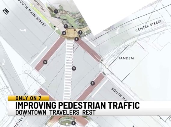
The proposed location near The Community Tap on South Main Street

Bike Walk Greenville has a Memorandum of Understanding with the City of Travelers Rest to raise funds for the purchase of a display counter manufactured by Eco-Counter. The City will install and maintain the counter. This display counter will have the same functionality as the display counter we partnered with the City of Greenville, that is located just north of Unity Park.

We learned the importance of data when we worked on our first project in Travelers Rest over six years ago when our volunteers manually counted people on foot and people on bikes at the Main Street intersection with Center Street and McElhaney Road.

The first display counter in South Carolina became reality with our successful fundraising in 2021 for the City of Greenville display counter

On October 10, 2022 we completed the fundraising and presented a check to Travelers Rest City Council

Featured

Data gather app news coverage

Thanks to the Greenville News and reporter Tamia Boyd for publishing this story

Only about 20 percent of bicycle accidents are initially reported to law enforcement across the country and South Carolina ranks as one of the most dangerous states for cyclists.

Facing these facts, Bike Walk Greenville is encouraging cyclists and others in the city to use an application developed by a data scientist at the University of California-Santa Barbara to help expand the data to improve safety and guide infrastructure improvements in the Upstate.

BikeMaps, created by UCSB data scientist Trisalyn Nelson, is a community engagement tool that allows bicyclists to map out and identify data on bicycle collisions, hazards and other safety amenities anonymously. BikeMaps can be accessed at BikeMaps.org on computer and phone.

The site shows real-time data on bike collisions and near-misses from cities around the United States and the world.

South Carolina ranked No. 5 as the most dangerous state for bicyclists, according to a study by Dolman Law, a personal injury firm. The state roughly had 3.5 cycling-related deaths per 100,000 deaths. That includes 178 total bicyclist fatalities between 2010 and 2019, according to the study. Throughout the 10-year study, the number of bicyclist deaths increased each year.

“When city planners are sitting down and thinking where should we start, where are our priorities areas, it’s not as clear because they don’t have all the local expertise,” Nelson said. “BikeMaps curates and collects all local expertise on what is safe and unsafe for bicyclists in cities.”

“Even if planning departments captured all the crash data, they would still be missing a lot of what is happening to cyclists on the roads,” Nelson said.

BikeMaps will work with Bike Walk Greenville to create hot spot maps that will show the worst places for biking in the city. 

City Council member Wil Brasington said the city is always in dialogue with community groups like BikeWalk Greenville that advocate for pedestrian and bicycle safety. 

“The City of Greenville definitively benefits from the instances where these groups share local and global data,” Brasington said.

Nelson said BikeMaps can help the city figure out the dangerous places and decide what investments are required to improve infrastructure. 

Carl Anderson, a board member of BikeWalk Greenville, said BikeMaps will help them in the long run to document events they can take to planners and let them know where exactly the problems are.

BikeMaps can show collisions, near misses, hazards, bike thefts and new infrastructure.

Nelson said it is particularly difficult to notify law enforcement of close calls. BikeMaps gives cyclists a chance to record and share that information.

Bike Walk Greenville executive Director Frank Mansbach said community engagement can drive change and predict and prevent crashes.

Although too soon to pick out trends in the data, Anderson said he has noticed a lot of the incidents reported were near areas with a heavy traffic flow. But it’s too early to correlate the heavy traffic with a safety concern. 

Like a lot of cyclists, Timothy Simpson has had a few close calls with drivers who weren’t paying attention. He recorded one of those incidents on BikeMaps.

“I had an incident in March where I had a driver intentionally try to run me over. I was biking home and I see lights behind me and I’m very visible wearing biking clothing. The car comes over the train tracks and spots me and blazes his horn then runs me off the road,” Simpson said.

He said he reported it to the police but nothing was done about it.

“I don’t take that route anymore,” he said.

Anderson said there have been reports on Swamp Rabbit Trail, but there is a tremendous amount of traffic on the trails.

There have been two cycling deaths at Swamp Rabbit Trail crossings since it opened in 2009.

Carli Brewer Soukup died on the trail in June 2021 when she was riding her bicycle across Sulphur Springs Road and was struck by a vehicle.

n June of 2019, Ellis Bailey was riding his bicycle when he was struck by a vehicle as he crossed the intersection of Watkins Bridge Road near Furman University.

“Hopefully this can be used by not only other Greenville bicyclists groups but the general public,” Anderson said.

Simpson said Greenville needs to have more multi-modal infrastructure like sidewalks, bike lanes and multi-use pathways like on the Swamp Rabbit Trail.

“These options make it easier for people who aren’t in cars to get around,” Simpson said.

Tamia Boyd is a Michigan native who covers breaking news in Greenville. Email her at tboyd@gannett.com, and follow her on Twitter @tamiamb. 

Featured

County Council Candidates answer our questions

Primary Elections were held on June 14, 2022. Candidates are shown below:

We have updated this post for the November 8, 2022 general election.

Make your voice heard in the South Carolina primary election! Early voting is open now and election day is June 14th (any runoff elections will be held June 28th).

You can check your registration status and sample ballot here

South Carolina has open primaries, which means that any registered voter can vote in the primary of their choice. Voters may only vote in one party’s primary. 

Governor McMaster recently signed into law No Excuse Early Voting, which means you can vote early without an excuse now in person at County Square. Check your sample ballot options, make a plan, and get yourself to the polls to make your voice heard! 

As a 501c3 non-profit we do not endorse candidates, we do this only to inform voters.

Our Questions

1. South Carolina and Greenville County have some of the highest pedestrian and cyclist fatality rates in the country. What do you think the main safety issues are for improving conditions for walking and biking in your district?

2. What funding sources do you recommend for completing local safety improvements for biking and walking?

3. Are there issues that are important to you, that you think Bike Walk Greenville and our audience in Greenville County should be aware of?

District 17 

    As development is increasing in rural Greenville County, what ideas do you have to promote resource conservation and quality of life for residents of District 17? 

District 19 

    Now that an underpass has been ruled out as an option for safe crossing of 253 on the Swamp Rabbit Trail, and construction of a bridge (in collaboration with the Union Bleachery developer) is a number of years out, what solutions would you recommend for immediate safety improvements at 253 and the Swamp Rabbit Trail?

District 23 

    The City of Greenville has been working on biking/walking infrastructure improvements to provide a needed connection between the Swamp Rabbit Trail and the West Village, with limited success to date. What ideas do you have to bring additional trail connectivity to West Greenville?

District 26:

 As development is increasing in rural Greenville County, what ideas do you have to promote resource conservation and quality of life for residents of District 26? 

Candidate Responses District 17

Sheryl Guarniero

Democrat

  1. In district 17, many of the roadways lack sidewalks and proper bike lanes. Additionally, there needs to be educational campaigns and signage to inform drivers to be aware of cyclists and pedestrian traffic. There needs to be increased visibility and for the roads in which sidewalks and bike lanes are not possible, we need to provide alternate routes for individuals using those modes of transport like extending the swamp rabbit trail or creating a similar right of way. 
  2. Funding is available from many resources. There are federal and state grants focused on transportation and safety enhancements from the DOT as well as other private organizations. If an area is booming with new housing or business development, the individual developers should be required to perform traffic studies which include the potential use by cyclists and pedestrians. The need to account for bike lanes and sidewalks should fall not only on the community but also the developers creating these new issues. 
  3. As a road cyclist and mountain biker myself, road safety and design is important as well as proper education for both drivers AND cyclists so we can share the road responsibly and safely. 

As development is increasing in rural Greenville County, what ideas do you have to promote resource conservation and quality of life for residents of District 17?  

We need to work in partnership with the local community and non-profits to ensure that we preserve green spaces and parks, redesign roadways where we are able to promote safety for all users, and support community engagement and pride through involvement and education (like local farmers markets, group hikes for all ages, collaborative community design that supports alternative modes of transport, etc.)


Joey Russo

Republican Primary Winner

  1. The way I look at this issue, like most of our issues in Greenville, come down to growth. For far too long we have been on our heels and reactionary to the infrastructure improvements that need to be made in order to grow well. Greenville County must make the investments that are necessary in our first responders and infrastructure to appropriately manage the growth that has been for so long unchecked. 
  2. We need to think creatively by utilizing public/private partnerships and federal grants in order to make these improvements. We must recognize that green space and access to trails increases our quality of life.
  3. I am a former Greenville County Sheriff’s Deputy and I have seen the tragic consequences of poorly designed roads that don’t allow for the safety of the driver’s, bikers, and walkers. I believe we are well past due for fresh vision and new leadership that is ready to tackle the issues we’re facing and I am ready to do my part in facilitating real solutions. 

 As development is increasing in rural Greenville County, what ideas do you have to promote resource conservation and quality of life for residents of District 17?  

I would promote utilizing various strategies for resource conservation. Through strategic/long term planning Greenville County can improve the safety for bikers/walkers along trails, parks, and roadways. Working closely with the private sector and grant funding for recreation areas, green space, and bike/walk paths that improve the quality of life that is so often damaged by growth. 

Joe Dill

Republican

  1. Our roads are too busy to handles bicycles, pedestrians, and cars. I was instrumental in creating the Swamp Rabbit Trail which was created to get bicycles and pedestrians off the road. Money needs to be spent to extend these trails.
  2. When the state paves a road now, it already includes a bicycle lane. On roads where bike lanes exist, state law needs to be enacted to require bikes stay in their lanes and cars in their lanes. This has been done in Washington State. It would make for a safer environment. Some County roads are too small for two cars to meet; much less adding cycling and walking to them. The state has C funds and the Federal enhancement grants that could be applied for that could be applied for and used for safety improvements.
  3. In my district people get real upset when all of the lane is taken up by bicycles. We have to find a way that we will not be penalized for living in such a pretty part of the county.

Simply Civics Greenville County has a podcast with both candidates

Candidate Responses District 19

Ivan Mathena

Republican

  1. There are a number of large roads, often in unincorporated areas, and that can lead to a lack of civic focus Re walking/cycling conditions. Crosswalks, traffic lights, biking lanes, and sidewalks are all options for improving walking/cycling conditions.
  2. I’d need to first sit down and assess the county budget VS expenditures before I make recommendations about how to pay for these improvements.
  3. In the middle of the campaign, my step-brother lost his life due to a skateboarding accident. He was not wearing a helmet, and happened to fall and hit his head at just the right angle. As an avid cyclist, I can’t tell you how many times I have hopped on a bike without a helmet. As a community, I think it’s important to stress the need for helmets. 

Now that an underpass has been ruled out as an option for safe crossing of 253 on the Swamp Rabbit Trail, and construction of a bridge (in collaboration with the Union Bleachery developer) is a number of years out, what solutions would you recommend for immediate safety improvements at 253 and the Swamp Rabbit Trail?

Maybe some railing so that cyclists/children can balance themselves once they hit the median. Additionally, that would give drivers an added issue that warrants concentration. Also, maybe some directional lanes, for the cyclists, so that there is an orderly transition across the road.

Wide open to suggestions. I *hate* crossing 253, on bikes, with my family.

Benton Blount

Republican Primary Winner

  1. My campaign started with Let’s Build a Bridge. That bridge is intended for the trail over highway 253. But there are many other safety issues that can be addressed on the trail.  A friend of mine once said you cannot climb Mt Everest all at once but it requires one step at a time. One step at a time we can make Greenville a better place to live.
  2. There a couple of sources that are available even beyond using property tax dollars. The accommodations tax is meant to be used for this type of community improvements. 
  3. Quality of Life is an important role that County Council can play in the community. There are more improvements that can be made to the trail but I am also focused on building more passive parks in the district and Greenville County. Additionally I believe we can collaborate with the mill water tower owners to get those rusty towers painted. I have said in my campaign materials could you imagine a painted water tower with a mural of the historic mill. Or even see Shoeless Joe Jackson as mural over the mill he worked and played mill baseball.

District 19 

Now that an underpass has been ruled out as an option for safe crossing of 253 on the Swamp Rabbit Trail, and construction of a bridge (in collaboration with the Union Bleachery developer) is a number of years out, what solutions would you recommend for immediate safety improvements at 253 and the Swamp Rabbit Trail?

 A bridge should have been built years ago. I will push to have a bridge built as soon as possible.

Jackie M. Clark did not respond to our questions

Willis Meadows did not respond to our questions

Simply Civics has a podcast with 3 of the 4 District 19 Candidates

Bussin’ podcast has interviews with Benton Blount and Jackie Clark

Candidate Responses District 23

David C. Mitchell

Democrat

1. Greenville’s growth has created an excellent environment for new and current residents to enjoy work and recreation in our beautiful downtown and surrounding areas. The tremendous growth and development have also caused pedestrian and cycling safety issues due to a lack of infrastructure that supports walkable communities and access to biking pathways.

As a Greenville County Council representative for District 23, I will focus on implementing the Unified Development Ordinance to address infrastructure development that effectively plans for growth to include safe roads, walkable communities, and biking lanes. My focus will be to grow smart while considering the needs of cyclists and pedestrians.

2. Funding is always a challenge when considering improvements to our county; however, there are some options for paying for improved infrastructure. We can seek more funding from the infrastructure bank that has allocations for sidewalks, bike lanes, and pedestrian crossways. We can also consider a penny sales tax with a transportation component that will provide a dedicated funding source to GTA/Greenlink to create a reliable bus system that is efficient and user-friendly. The goal will be to generate funding resources to address the lack of safe and accessible pedestrians and pathways for pedestrians and cyclists.

3. Income-Based Affordable Housing in District 23 is needed now. Lack of income-based housing impacts every facet of our lives. It affects our economy as companies go where their employees can afford to live. It impacts our historic communities as they get swept away under gentrification. It impacts our young people and low-income earners as they can’t find affordable homes. As a member of the Greenville County Council, I will work to ensure we find solutions

The county needs Improved Access to Reliable Greenville Transit Authority service for District 23 means better access to better jobs, shopping, and recreational activities. As a member of the Council, I’ll prioritize securing a dedicated funding source for Greenlink service expansion for our community, improved routes, and the frequency of bus service. 

The City of Greenville has been working on biking/walking infrastructure improvements to provide a needed connection between the Swamp Rabbit Trail and the West Village, with limited success to date. What ideas do you have to bring additional trail connectivity to West Greenville?

We have to focus on planning the future expansion of the Swamp Rabbit Trail and the West Village by allocating funds that adequately address the needs and desires of the local communities. We have available funds in tourism fees that can address the trail infrastructure. In the same way, we promote the development of communities; we need to have the same focus on the smart and safe development of our trails and parks. We have to budget money equally on trail expansion and upkeep, similarly to investing in local parks. Tourism dollars are limited; however, we can better prioritize projects that have the same level of importance as other recreational infrastructure in the city and county of Greenville.

Alan Mitchell

Democrat Primary Winner

1. Many of the roads and streets in Greenville County have worn pavement edges and ditches on the sides. These conditions can cause cyclists and even drivers in cars to lose control when close to the pavement edges. Streets are narrow and do not leave much room for maneuverability for cars when cyclist are on the roads. Also, we do not have enough bike lanes and chevrons marked on the pavement in higher traffic areas. At night, cyclist need to wear more reflective apparel and have more reflectors and/ or lights on their bikes. Streets need better lighting for evening and early morning riding. Everyone needs to be better educated on the rules of the roads for cyclists and drivers, and we need to watch for cyclists like we do for motorcycles.

2.The Build Back Better America infrastructure bill can provide a much needed boost to the road and streetscape improvements that are needed and overdue. We should also be able to secure additional State, County, and City funds to do what is necessary to keep the citizens safe.

3.Many studies have been completed over the years that deal with cyclist and pedestrian safety. We need to review these studies and implement the strategies that are enumerated in those studies. Some of the elements in these studies call for more bike and walking trails, improved road surfaces, road edge design elements, pavement markings, signage, better lighting and more. It’s time to pause studying and implement the improvements that are already called out in previous studies.

There is much growth and development occurring in West Greenville. Much of it is spearheaded by outside developers. We can get them involved to design the needed interconnectivity into their development plans and help fund the trail connections. All of these projects need to be balanced for the motorized vehicles, cyclists, and the walkers. Then, if the City, County, and State can provide a fair share, the burden is not on any one entity. Additionally, we should be able and willing to secure Federal funding to make the trail connections a reality. We all need to coordinate and work together on these and similar projects.

Ben Carper

Republican

Candidate Responses District 26

Lynn Ballard

Republican

1. My District covers 230 square miles (the Southern 1/3 of the County).  Much of the district is flat and farmland with many narrow, winding roads.  I have spoken with the leader of Greenville Spinners about a couple of roads where the bicyclists were in potential danger, and he shared it with the group.  If the cyclists will ride no more than two abreast it will be much safer for them and for the vehicles.  When there is a large group of cyclists, and they are riding three or four abreast it is very dangerous.  Since I spoke with leader of the group, I have not come upon large groups riding together in that manner.  Since there are very few sidewalks in my District, I recommend that walking be done on the trails at the local parks – Cedar Falls Park and Loretta Wood Park – bot of which have great walking trails.

2. Biking and walking are generally considered to be recreational activities.  Greenville County has an excellent Parks and Recreation Department.  I would recommend that funding for projects, etc. be requested through this Department.  Also, there may be various grants available for some of these projects.

3.The biggest issue that concerns me was mentioned in my answer to question 1.  While the population in my District is spread out over a vast area, that brings with it much less traffic than in more populated areas.  It is not unusual to drive down some of the roads in my District and never see or pass another vehicle.  This situation would be very appealing to cyclists, in my opinion, but it also carries an element of danger.  Since most drivers are used to driving on roads with little traffic they can tend to become “too familiar” with the route.  We all try to be alert to any changing conditions as we drive, but it is important for cyclists to also be very alert to oncoming traffic from both directions.

The biggest issue that concerns me was mentioned in my answer to question 1.  While the population in my District is spread out over a vast area, that brings with it much less traffic than in more populated areas.  It is not unusual to drive down some of the roads in my District and never see or pass another vehicle.  This situation would be very appealing to cyclists, in my opinion, but it also carries an element of danger.  Since most drivers are used to driving on roads with little traffic they can tend to become “too familiar” with the route.  We all try to be alert to any changing conditions as we drive, but it is important for cyclists to also be very alert to oncoming traffic from both directions.

Rick Bradley did not respond to our questions

Greenville Chamber Ratings

The Greenville Chamber actively advocates for policies and supports business leaders and their representatives in forwarding pro-business legislation that will benefit the Upstate.

Every year, we issue ratings for candidates running for office throughout Greenville to help the business community make decisions about which candidate to support. The Chamber does not endorse candidates.

Ratings are based upon a candidate’s written responses to business-related questions followed by in-person interviews conducted by local business leaders. You can find their ratings at this link

Featured

The Lakeview Link Timeline

From idea to project completion took nearly nine years

The Lakeview Link is a 4/10 mile trail for biking and walking that connects Lakeview Middle School on Old Buncombe Road, and the surrounding community to the Greenline of the Prisma Health Swamp Rabbit Trail.

Momentum Bike Clubs have after school programs for the students to learn the pleasure and freedom of riding bikes, and this trail allows them to safely ride the SRT.

A one minute video of the timeline

Greenville County negotiations and execution of right of way  easements took four years from 2013 to August 2017

•Conversations with property owners started in earnest in June 2013

•Duke Energy signed the agreement in January 2015

•The School District of Greenville County signed the agreement in August 2017

The Fundraising Phase came next

•In August 2017 The County announces ROW easements have been obtained

•Bike Walk Greenville started discussions with the County that month

•A public private partnership agreement was negotiated with the County and a Memorandum of Understanding was executed in December 2017

•In January 2018 Bike Walk Greenville Launched a Fundraising Campaign with a short professionally produced video

The fundraising campaign was successfully completed in June 2018

County Crews started grading in November 2018

The trail was paved in June 2019

Bike Walk Greenville commissioned public art by Charles Pate Jr. that was donated to Greenville County and installed in December 2019

This statue has become the background for photographs by countless trail users and clearly defines our advocacy that ” We all need a safe pace to walk and ride a bike.”

In June 2020 paving was done connecting the last section to the main SRT

Bike Walk Greenville hired Earth Design Inc to construct the entrance plaza that was completed in January 2021

The day lilies were planted in March 2022 and the kiosk was installed in May 2022

Featured

Establishing a safer route to school

By Nathan and Katie Dawson

Students at Rudolph Gordon School in the city of Fountain Inn enjoyed a better option for walking to and from school for the first time this week. A new mid-block crosswalk was established by SCDOT at a location providing better access, visibility and safety for student walkers. There were a lot of factors that went into our community’s crosswalk completion including suburban growth, an injury, community work, and funding advocacy to improve infrastructure and police service.

Our family sold our house at the beginning of 2020 and moved from Abingdon, VA to be near family in the Carolinas. We immediately felt at home in Fountain Inn since it had a similar small-town feel and close proximity to mountainous adventures. With young kids, we knew Jones Mill Crossing was the community for us since we work from home and our commute to Rudolph Gordon School would be our biggest for the next decade as the school is the only K-8 school in Greenville County.

Once the kids started school, we realized the route to school was challenging for young kids to make in the early morning hours consistently as it required taking an indirect route and crossing at an intersection with heavy traffic along with several other smaller crossings in front of moving cars in the car line. We started reaching out to government entities to add our voices of concern via phone calls and emails, but so much more was required to get the new crosswalk established by SCDOT and Greenville County Schools (GCS).

Suburban Growth Factors

The first request for a crosswalk was made by the Jones Mill Crossing neighborhood developer, Cothran Properties, in the fall of 2016. Cothran Properties requested to add the mid-block crosswalk during the early stages of the design of Jones Mill Crossing when Rudolph Gordon was just an elementary school. The mid-block crosswalk was denied at the time due to SCDOT’s requirement for a police officer or county crossing guard at a mid-block crosswalk and a lack of commitment to a sidewalk by GCS to connect it on school property.

Parents voiced concern and requested the crosswalk to be added in the last few years but an increase in population density escalated the need. Houses in our community are built close together and near the school so many households are positioned to benefit from this close proximity with an opportunity to walk kids to school.

Over the last 6 years, more homes have been built and the neighborhood finally reached capacity in early 2022 with 136 homes and over 200 pedestrian crossing occurrences daily during school commute times at Scuffletown Road. Up until 2020, not all grades were included at Rudolph Gordon as they gradually added an upper grade each year: 6th grade in 2018, 7th grade in 2019, and finally 8th grade in 2020. The new Fountain Inn High School also opened 2 miles away starting with the 9th grade in the fall of 2021. These new students at the middle school and the new high school are adding to a drastic increase in traffic on Scuffletown and Jones Mill roads during school commute hours. As pandemic-era virtual learning mostly subsided, students returned to in-person learning in droves making the crossing of Scuffletown Road increasingly dangerous.

Injury incident

On September 3, 2021, a father and his 8 and 5-year-old daughters were hit by a truck at the signalized intersection. They were crossing with the walk symbol lit, following all of the rules yet still suffered injuries, time away from work and school, and an increased fear in walking to school. Thankfully, the injuries were not life-threatening, but it reinforced the need to make improvements in creating a safer route to school for every person in our community.

Unfortunately, it often takes a negative incident to spur government action to actually spend money to address problems in a community, particularly when it comes to pedestrian safety.

Community Work

Government officials held a meeting in the weeks after the family’s injury but did not include community members. Officials began some improvements to the stop light to yield moderate risk reduction such as adding all red in every direction when the walk signs are lit. As a community, we continued to work toward adding the mid-block crosswalk by gathering data on the number of times pedestrians cross Scuffletown Road, organizing a walk-to-school day event attracting print and TV media attention in October, and finally organizing a walk audit in November with key stakeholders that have never walked the route during school morning commute hours.  

The walk audit resulted in SCDOT stating the same thing that was told to the developer Cothran Properties 6 years ago: 1) the school must include a connecting sidewalk to the crosswalk and 2) students must have a crossing guard or police officer present during morning and afternoon school commute times. SCDOT’s requirements have never changed, but at the November walk audit meeting Greenville County Schools finally agreed to add a sidewalk on Rudolph Gordon School property costing tens of thousands of dollars, fulfilling one of SCDOT’s requirements.

This was a huge victory but obtaining a commitment for an officer or crossing guard (through county or city funds) proved to be a greater challenge as both denied any willingness to commit until the crosswalk is established.

Staffing a county crossing guard position is a lengthy process – it requires a traffic study to be performed at a crosswalk that already exists. If the road is deemed too busy, a crossing guard cannot be established due to safety concerns for the crossing guard. If a position is selected for funding, the county has had great difficulty in hiring and keeping the positions staffed at the hourly rates they are able to pay.  

Money

SCDOT would not establish the crosswalk until an officer was committed yet the city and county would not consider staffing a crossing guard until a crosswalk existed – presenting a chicken and egg scenario that had no resolution other than committing to pay for the officer through private funding in order to jumpstart the entire process.

Although the city of Fountain Inn was unable to provide an officer during November negotiations, there was willingness and availability for an officer to be hired at a cost. Homes within a 1-mile radius from the school with a city of Fountain Inn address pay over half a million dollars in taxes each year and nearly $200,000 specifically to the city of Fountain Inn. With a police budget of $2.6 million, the cost of service requested is 0.2% of the annual budget and approximately 4% of the tax revenue for Fountain Inn generated by the homes within walking distance of the school. After recent meetings, the City of Fountain Inn leaders have been favorable about funding the morning officer as a city provided service in their 2023-2024 annual budget ,but no formal commitment has yet been made.

We want to thank Bike Walk Greenville as they provided resources, administrative support, web space and a funding base at no cost to our community. Our funding goal is nearly met as many generous businesses and individuals have contributed to the fund, including larger donations from Toll Brothers and The Spinks Family Foundation. Ultimately, the crosswalk traffic officer needs to move to public funding. We are hopeful about the city of Fountain Inn’s efforts to make improvements for pedestrian safety, and grateful to SCDOT and Greenville County Schools for following through with their commitments to improve walkability for students.

Achieving a victory for the children of Rudolph Gordon School is something to be celebrated, but there are dozens more schools with no walkability or focus on pedestrian safety in Greenville County, so a great deal of work remains to be done in the coming years.

If you would like to give towards this project, donations can be made here to the Capital Project Fund.

Featured

The friendliest bike rider on the SRT and his trail etiquette tips

Shone Phelps has been waving at me and saying “Hello Sir!” for several years it seems. I was talking to our Board Chair Mary McGowan about him recently, and she said she sees him all the time, and wondered who he was. On my Sunday morning ride on March 6, 2022, after he waved and said hello, I turned around and caught up with him and the two gentlemen he was riding with when the stopped at Swamp Rabbit Station. I introduced myself, and he agreed to be interviewed. You will enjoy meeting Shone in this short video!

We have kept in touch with Shone since this first introduction in March, and asked him to do a video about SRT etiquette. Tim Simpson Jr volunteered to produce the video that we released on August 14, 2022. Our friends at GVL Today featured Shone on August 17, 2022

Featured

Dangerous by Design in Greenville County

Socioeconomic and Infrastructure Disparity between Poor and Wealthy Neighborhoods in Greenville, SC

a video by Furman University Senior Loise Aleria


As an intern with Bike Walk Greenville for the Fall 2021 semester I investigated the deaths along major roads that have been designed only to move motor vehicles as fast as possible, with little consideration for the safety of the people who live along these corridors.

The May 29, 2021 death of Brittany Langely Lawson on Augusta Street resulted in unprecedented action by the City of Greenville to study and plan implementation of changes to make this road safer for pedestrians.

During my internship there were far more deaths in the poorest parts of Greenville County with no call to action by County or State elected officials to implement safer conditions for people on foot along these SCDOT roads.

This short video summarizes my findings and urges action for implementing proven solutions to reduce deaths of vulnerable road users.

Loise Aleria

Since the completion of Loise’s internship, Bike Walk Greenville has been exploring a path towards funding a professional study for enhanced pedestrian safety on White Horse Road. After meeting with Keith Brockington, the Greenville County Transportation Manager in December, 2021, we were invited to present at the January 31, 2022 GPATS (Greenville-Pickens Area Transportation Study) study team meeting. We then received an invitation from Senator Rex Rice to present at the March 7, 2022 GPATS Policy Committee Meeting, where our presentation was well received and resulted in a resolution for staff to follow up with SCDOT about pedestrian safety studies on White Horse Road and other major corridors. The slides used are in the below video:

In discussions at the March 7, 2022 meeting we learned from SCDOT commissioner Woody Willard that SCDOT had bid some pedestrian improvements for White Horse Road in 2021, but the bids came in above the budget, so no construction was done. We subsequently received the conceptual drawings for this bid package, and indeed these are needed improvements as shown below:

Thanks to the Greenville News for covering the GPATS meeting and following up with SCDOT. On April 5, 2022 they published this story by reporter Tamia Boyd:

https://www.greenvilleonline.com/story/news/2022/04/05/scdot-re-bids-safety-improvement-project-white-horse-road/9426110002/

On April 25, 2022 The GPATS Study Team met, and the letter to SCDOT from GPATS was made public.

Featured

December 2021 Update

Since 2013, Bike Walk Greenville has been advocating for safer infrastructure for people on foot and on bikes. Read on to learn more about our past successes and future projects! To support our work, please consider making a tax deductible end of year donation. We appreciate your support!

Our first achievement was raising funds for the Greenville County Safe Routes Plan, prepared by consulting group Alta Planning, that was adopted by County Council.
 

100 biking and walking projects valued at $47MM would have been funded by the 2014 penny tax referendum for road projects, but this measure was defeated at the polls.
 7 years later these important projects remain unfunded, and we will continue our advocacy for the prioritizing and financing of these projects.

In 2016 we partnered with the City of Greenville to build a demonstration protected bike lane on East Broad Street – the first in South Carolina!

We are pleased to see that the City is responding to demand and feedback, is currently planning new protected bike lane projects.

In 2016, our volunteers counted Swamp Rabbit Trail users in downtown Travelers Rest, and used the data to advocate for a safer diagonal crossing with all motor vehicles stopped.
 In 2020 the City of Travelers Rest appropriated funding; the project has been permitted and construction is anticipated to begin soon!

In 2017-18 we raised funding for the construction of the Lakeview Link. This public-private partnership project with Greenville County provides a helpful connection between Old Buncombe Road at Lakeview Middle School to the Swamp Rabbit Trail.

The Lakeview Link was paved in June 2019, allowing the Lakeview Middle School students safe access to the SRT network.

Trail connectivity projects are a high priority for our advocacy, and we look forward to partnering with other organizations to make more projects like this one a reality!

In December 2019, a bronze sculpture by Charles Pate Jr that we donated to the County was installed on the Lakeview Link Plaza.

Our message, “we all need safe places to walk and ride a bike” has now been seen by hundreds of thousands of trail users and been used as a background for countless photos.

Our 3-year advocacy with the City of Greenville to fund a dedicated staff position of Mobility Coordinator became reality in 2019 with the hiring of Calin Owens for that position.

Our advocacy that started in 2017 to smooth the root bumps that plagued Swamp Rabbit Trail led to the successful County repaving project in 2020-21.

Our volunteer Bike Valet returned this fall and we enjoyed seeing some new and familiar faces after time spent apart! We look forward to continuing to partner with the City of Greenville at Artisphere and Fall For Greenville to provide free, convenient event parking for bikes. Stay tuned for more permanent bike parking amenities in Greenville as well!

We raised funding for the City of Greenville to install a digital display counter of Swamp Rabbit Trail users.  It is expected that installation (just north of Unity Park at Willard Street) will be completed by year end 2021.

We look forward to using this trail data to advocate for more prioritization and funding of infrastructure projects that make our community safer and healthier for everyone. 


Featured

3 % of people in Greenville County live in a walkable community

We originally published this post on December 27, 2016.

On September 28, 2022 we presented about walkability to the Upstate Forever Citizen’s Planning Academy and we asked the participants what percentage of Greenville County residents live in a walkable community, and the guesses were all very close to our 2016 analysis!

We decided to look again at the below data, and found that the County population as of July 2021 is 533,834, which is a 8.6% increase from the below data, and the City of Greenville has grown 11.6%.  Travelers Rest has grown 69.8% from the 2015 to a population of 7,771.

Unfortunately the walkscore.com website has not updated the population numbers to recognize this growth.  Further to complicate a new analysis, there is no alignment between the official census tracts and walk score’s neighborhoods.  Travelers Rest has a walk score of 48, and one can argue that is should be considered somewhat walkable.  So perhaps the walkable percentage now exceeds the 3% and is near 4%.

The original post:

The website walkscore.com allows users to find locations that are walkable, and makes money by advertising apartments and homes in the searched location.

They state, “We believe that walkable neighborhoods with access to public transit, better commutes, and proximity to the people and places you love are the key to a happier, healthier and more sustainable lifestyle.”

A recent CNU journal post, What is a Liveable Community Anyway?

“A walkable community is the most common term to describe the alternative to drive-only suburbia.

Former US Transportation Secretary Ray LaHood defined livability as “a community where you can take kids to school, go to work, see a doctor, go to the grocery store, have dinner and a movie, and play with your kids in a park, all without having to get into a car.”

A walkable community is a livable community, according to the plainspoken LaHood. Walkability allows for access, connection, and diversity of experience.

The concept is a profound one:  Life changes depending on whether a community is built around walking or driving.”

Here are the metrics for Greenville County:

Why do people not bike or walk for transportation?

  • 97 % have to use a car to run all errands
  • No safe infrastructure / suburban sprawl infrastructure

Downtown Greenville will grow by approximately 5,000 people when the  construction of apartments and condos currently permitted are completed.  This will increase the percent of Greenville County residents living in a walkable community by 1/2 of one percent.

It is unlikely that urban development in the other municipalities in our County will change this metric, as these are small urban cores compared to Greenville.

This writer is among the 3 percent of Greenville County residents who are fortunate enough to live in a walkable community and can attest how liveable it is!